Gulmarg Terrain Map
Gulmarg does not work the way most ski resorts work, and the trail map you find at the gondola base tells you almost nothing about where people actually ski here.
The controlled, patrolled area covers one bowl. Everything else, and it is a lot of everything else, sits outside that boundary. No patrol, no closure signs, no netting, no marked run numbers. Around seventeen or eighteen bowls of open terrain plus the tree zones below them, and a mountain that averages roughly fourteen metres of snow a season.
That is the appeal. It is also the reason people take guides here who would never bother in Europe.
This page walks through the mountain zone by zone, from the nursery slopes to the terrain you need a hike and a stable snowpack to reach.
The mountain in numbers
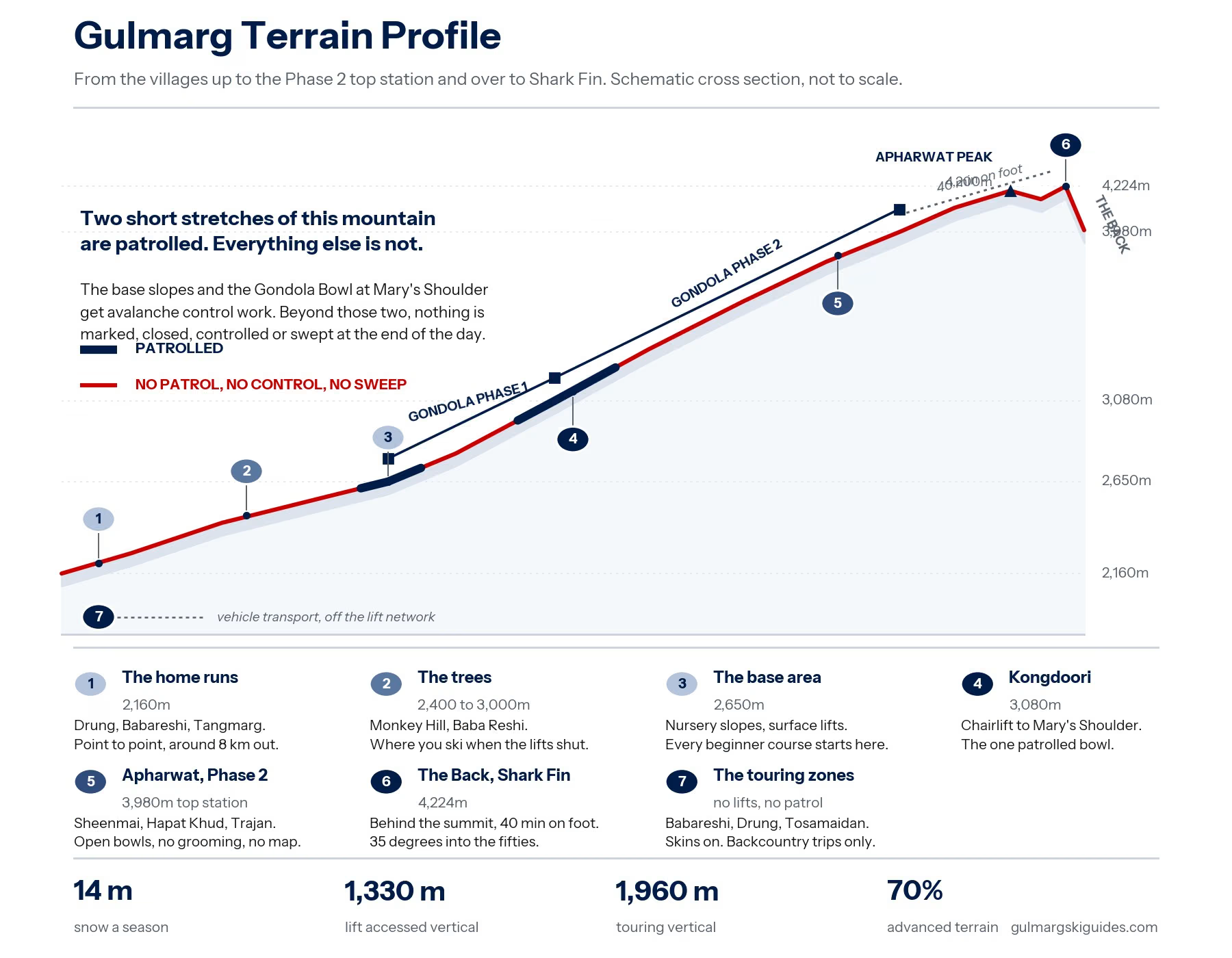
- Gulmarg village: around 2,650m
- Kongdoori, Gondola Phase 1 top: around 3,080m
- Apharwat, Gondola Phase 2 top: around 3,980m
- Highest touring access: around 4,224m at Shark Fin
- Lowest skiable point: around 2,160m at Drung
- Lift accessed vertical: roughly 1,330m
- Touring accessed vertical: roughly 1,960m
- Average annual snowfall: around 14 metres
- Terrain split: roughly 10% beginner, 20% intermediate, 70% advanced
- Average pitch: around 38 degrees
- Lifts: two gondolas, one chairlift, surface lifts
- Season: late December to late March
That terrain split is the number worth sitting with. Seventy percent of this mountain is advanced, and almost none of it is patrolled.
Zone 1: The base area, around 2,650m
The nursery slopes sit in Gulmarg village itself, on and around the golf course, served by surface lifts. Short runs, gentle pitch, soft landings.
This is where every beginner course we run starts, and where most people spend their first two or three days. It is unglamorous and it is exactly right for learning. Falling over at 2,650m on a slope you can walk back up is a very different experience from falling over anywhere higher.
Worth knowing: the base surface lifts have historically not been open to snowboarders, so beginner riders either walk back up or get towed. Ask us before you arrive and we will tell you where things stand for the current season.
Suits: complete beginners, first turns, nervous first timers Our packages here: all beginner ski and snowboard courses, days one to three
Zone 2: Kongdoori and Mary's Shoulder, around 3,080m
Gondola Phase 1 lifts you from the village to Kongdoori, a plateau at roughly 3,080m with food stalls, sledging and the start of the real skiing. The ride takes ten to fifteen minutes.
From Kongdoori a chairlift climbs to Mary's Shoulder. This is the main Gondola Bowl, and it is the one part of Gulmarg that sits inside the controlled, patrolled ski area. Some of it gets groomed, though not on any reliable schedule, so a run that was corduroy yesterday may be chopped powder today.
For a progressing skier this is the step up from the base. Wider, longer, steeper, and with enough variation to work on turns that actually mean something. Lower intermediates can handle the chairlift terrain on days when it has been groomed, and should think twice on days when it has not.
Suits: improving beginners, intermediates, anyone building confidence before going higher Our packages here: beginner courses from around day four, plus warm up laps on freeride trips
Zone 3: Apharwat and the Phase 2 terrain, around 3,980m
Phase 2 runs from Kongdoori to the top station at roughly 3,980m, a twelve minute ride that puts you above the treeline in a landscape of open snowfields and rock.
This is where Gulmarg earns its reputation, and where the mountain stops being a resort.
Turn left out of the top station and you reach a run of bowls including Sheenmai, Hapat Khud, Trajan and Saffron. No hiking required. You unload and you ski. Turn right and there is a much larger spread of terrain, so much of it that lines can stay untracked for days after a storm, sometimes weeks.
None of it is inside the controlled area. All of it is avalanche terrain.
The snow up here is light and dry compared with most of the Alps, and it sits on slopes that average around 38 degrees. That combination is the whole reason people fly in from Japan and Europe, and it is also the reason the snowpack needs reading properly before anyone drops in.
Suits: confident off piste skiers and riders, with a guide Our packages here: all freeride ski and snowboard packages
Zone 4: The Back and Shark Fin, up to around 4,224m
North of the top station, roughly forty minutes on foot along the ridge, is Shark Fin. It is the steepest well known terrain in Gulmarg, with pitches running from around 35 degrees into the fifties and beyond in places, and a descent of several hundred metres.
Beyond it sits Great White, a similar face with fewer cliffs and cleaner snow, plus a set of chutes and lines that drop toward a frozen lake.
This is expert terrain in the real sense of the word. It needs a stable snowpack, a guide who has been watching that snowpack all season, and skiing that holds up when the slope is steep and the consequences are serious. Guides do not take groups here on reputation alone. They take them here after several days of watching how the group skis.
Suits: experienced off piste skiers and riders, in the right conditions only Our packages here: freeride and backcountry trips, on the guide's call
Zone 5: The trees, roughly 2,400m to 3,000m
Monkey Hill, Baba Reshi and the forests above Tangmarg are the answer to the question every visitor eventually asks: what happens when the gondola shuts?
Because it does shut. Storms close the lifts, and the storms are usually what brought you here in the first place. The tree zones stay skiable when the alpine is a whiteout, because the trees give you contrast and shelter that open terrain cannot.
They are not easy. The gaps between trees are generous by Japanese standards, but the pitch runs around 35 degrees and tree skiing punishes hesitation. On a big snow day they are the best skiing on the mountain.
Suits: confident off piste skiers on storm days Our packages here: freeride packages, when the weather closes the lifts
Zone 6: The home runs, down to around 2,160m
Gulmarg's long descents run off the mountain and out to the villages below. Drung sits at roughly 2,160m and is the lowest skiable point on this side, reached by a descent of around eight kilometres that ranks among the longest off piste runs anywhere. Babareshi and Tangmarg have their own versions.
These are point to point days rather than lap days. You finish in a village, not at a lift, and a vehicle brings you home. Sometimes there is tea involved.
Suits: intermediate to advanced off piste skiers with a guide and transport arranged Our packages here: freeride and backcountry trips
Zone 7: The touring zones
Beyond the lift network sit the zones we run our backcountry trips into. Babareshi, Drung and Tosamaidan all need vehicle transport to reach, and all of them need skins to move around once you are there.
There is no infrastructure out here. No lifts, no patrol, no marked routes, and no quick way out if something goes wrong. That is why every backcountry booking goes out with walkie talkies, a snow science kit for digging and reading pits, and full avalanche rescue gear.
Closer in, Khilanmarg, Sunshine Peak and the Far Far Side are reachable by hiking or skinning from the lift network, and they open up a lot of terrain for a relatively short walk.
Suits: skiers and splitboarders already comfortable on skins Our packages here: all backcountry ski and splitboard trips
What is controlled and what is not
This is the single most misunderstood thing about Gulmarg, so it is worth stating plainly.
Inside the controlled area: the main Gondola Bowl at Mary's Shoulder, and the base slopes. Patrolled. Avalanche work gets done here.
Everything else: not controlled, not patrolled, not swept at the end of the day. If you ski out of bounds and something goes wrong, the response comes from whoever is standing next to you.
Gulmarg does have an avalanche advisory, published through the Gulmarg Avalanche Centre, and it is worth reading every morning whether you are skiing with us or not. But an advisory tells you the regional picture. It does not tell you whether the specific slope in front of you has a wind loaded pocket sitting on a weak layer. That judgement is what a guide is for.
Matching terrain to your ability
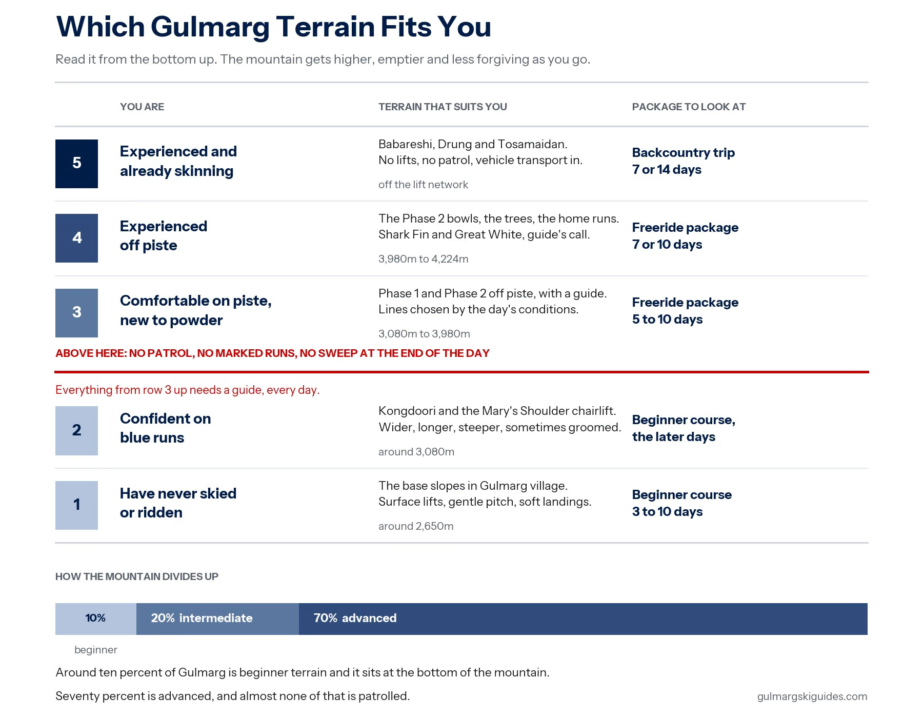
Have never skied or ridden
Terrain: Base slopes, around 2,650m
Package: Beginner courses, 3 to 10 days
Confident on blue runs
Terrain: Kongdoori, Mary's Shoulder chairlift
Package: Beginner course, later days
Comfortable on piste, new to powder
Terrain: Phase 1 and Phase 2 off piste, guided
Package: Freeride packages, 5 to 10 days
Experienced off piste
Terrain: Phase 2 bowls, the trees, the home runs
Package: Freeride packages, 7 or 10 days
Experienced and skinning already
Terrain: Babareshi, Drung, Tosamaidan
Package: Backcountry trips, 7 or 14 days
Frequently asked questions
Is there an official Gulmarg trail map?
There is one for the controlled area, and it covers a small fraction of what people actually ski. The out of bounds terrain has no official map, no run names on a signboard, and no markers. Local knowledge does the job a trail map does elsewhere.
Can I ski the off piste terrain without a guide?
Legally, nobody stops you. Practically, it is avalanche terrain with no patrol, no closures and no sweep, and people have died here. Skiers have been caught in avalanches on slopes that looked fine from the top. If you are going out of bounds, go with someone who knows the snowpack.
How much of Gulmarg can a beginner actually use?
Around ten percent of the terrain is beginner terrain, and it sits at the bottom of the mountain. That sounds limiting and it is, but ten percent of a mountain this size is still plenty for a first week, and the base slopes are genuinely good for learning.
When is the snow best?
The season runs from late December to late March. Snow generally builds through January and February, which is when most of our trips run. March can be excellent and can also turn spring like quickly.
What happens on a whiteout day?
The lifts close, and the trees open. Monkey Hill, Baba Reshi and the Tangmarg forests are the standard answer, and a good storm day in the trees often beats a bluebird day up top.
Do I need altitude acclimatisation?
The top station sits just under 4,000m, which is high enough that some people feel it on the first day. Most guests adjust within a day or two. Take the first morning gently, drink more water than you think you need, and tell your guide if your head is pounding.